
Thirty Billion Images Nobody Knew They Were Taking
In 2016, hundreds of millions of people took to the streets with their phones held high, chasing virtual creatures. Little did they know they were simultaneously building the most detailed visual map of urban environments ever assembled. Every corner photographed to catch a Pokémon, every statue scanned to redeem in-game rewards, every façade captured from different angles — all of it got stored, tagged, and georeferenced.
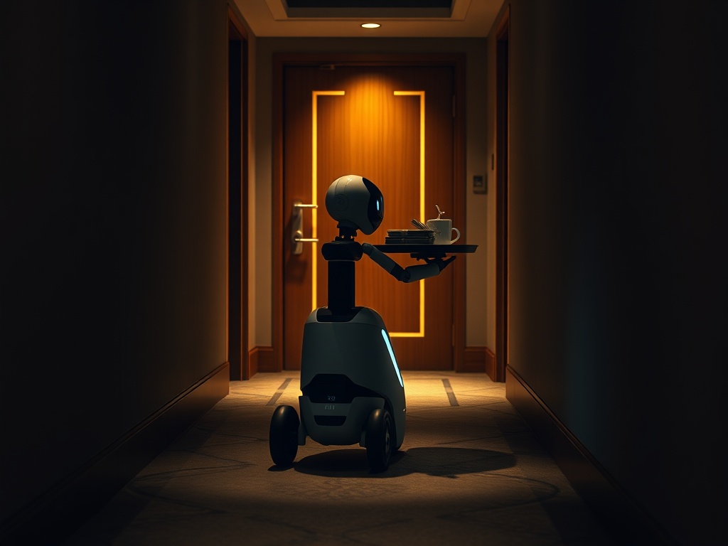
Today, that archive contains over 30 billion images. And Niantic has just licensed it to guide delivery robots along sidewalks in real-world cities.
This week, Niantic Spatial announced a partnership with Coco Robotics to equip its autonomous robots with a Visual Positioning System (VPS) trained on that repository. The accuracy reported by their engineers reaches within a few centimeters, an order of magnitude higher than what conventional GPS offers in dense urban environments. Niantic Spatial's CEO, John Hanke, summed it up succinctly: getting Pikachu to move realistically down a street and ensuring a robot can cross it safely are fundamentally the same engineering problem.
Why GPS Falls Short and What Vision Changes
GPS works by triangulating satellite signals. In open fields, the accuracy is acceptable. But in an urban canyon —high-rise buildings, overpasses, pedestrian tunnels— the signals bounce, degrade, and produce drifts of several meters. For a human driver, those meters are irrelevant. For a robot that must navigate among pedestrians, cross a bike lane, and stop precisely in front of a doorway, they mean the difference between operating and colliding.
The VPS solves the problem differently: instead of seeking satellites, it compares what the robot's camera sees against the stored visual inventory. It recognizes façades, steps, signs, and flowerpots as spatial anchor points. If the environment has been photographed from multiple angles —and in cities where Pokémon GO was popular, it was done with a density hard to replicate by any mapping vehicle fleet— the robot knows exactly where it is without relying on an external signal that may fail.
The Coco 2 model, unveiled in February 2026, is the first hardware designed to leverage this system on a commercial scale. It operates on sidewalks, bike lanes, and some roadway segments, significantly expanding coverage compared to previous prototypes which were limited to university campuses and reportedly got lost when trying to cross a regular street.
The Asset Nobody Valuated While It Accumulated
What Niantic built was not intentionally a robotic navigation database. It was a gaming mechanic that, as a side effect, generated an asset with independent economic value. That distinction is important because it explains the structural advantage Niantic holds over any competitor trying to replicate the dataset today.
Creating it from scratch would take years of deploying vehicle fleets for mapping, contracts with municipalities, agreements to access private spaces, and a budget that no robotics startup can afford as initial expenditure. Niantic accumulated this data because its users generated it for free, motivated by points, virtual creatures, and the satisfaction of completing missions. The marginal cost of each additional image was, in practice, zero.
This is the most interesting mechanic from a platform economy perspective: the data was produced with a structure of incentives that had nothing to do with its final use. The player never perceived they were working for a future logistics product. Niantic didn't plan it that way from the outset either. The value emerged from accumulation, not from a deliberate design towards that end.
The last-mile delivery market —the final stretch between a distribution center and the customer's door— captures a disproportionately large share of the total logistics costs in e-commerce. Industry estimates put this segment between 40% and 53% of the total cost of the chain. Autonomous robots are an obvious answer to the problem, but their adoption has been hindered precisely by the navigation failures that VPS promises to resolve. If the technology works at scale, the impact on the unit economics of operators like Coco Robotics could be substantial: less human backup intervention, faster routes, fewer delivery errors.
The competitive market around this bet is already moving. DoorDash introduced its own autonomous robot with a maximum speed of 32 km/h. Aurora operates autonomous freight trucks in Texas. Waymo and Tesla continue refining their fleets with real driving data. What sets Niantic apart is that its advantage does not lie in the hardware or the driving algorithm: it lies in the volume and density of the pre-existing visual dataset, which its robotics competitors cannot purchase because it does not exist elsewhere with that granularity.
The Living Map as Infrastructure, Not a Product
What Niantic Spatial is building is not a one-off solution for Coco Robotics. It’s a layer of geospatial infrastructure that can be licensed to any system needing precise positioning in urban environments: delivery drones, autonomous wheelchairs, guidance systems for visually impaired individuals, infrastructure inspection vehicles.
Every robot deployed with active VPS also contributes new images to the system, updating it with recent changes in the environment: construction work, new businesses, modified street furniture. This makes the map a self-updating asset that becomes more valuable with use, generating a cumulative advantage that is hard to erode.
The model has a clear financial logic: Niantic does not manufacture robots nor competes in logistics. It licenses a layer of spatial intelligence and charges for access to it. The more operators adopt VPS, the more data it receives, the more accurate the system becomes, and the harder it is for a competitor to offer something equivalent at a comparable price.
This doesn’t eliminate risks. The question of what data exactly gets transferred to the central system, who controls it, and under what conditions it could be shared with third parties is relevant from a regulatory perspective, especially in jurisdictions with strict privacy legislation. Niantic has stated it has no plans to make VPS available to law enforcement, but the absence of a publicly audited contractual framework regarding the secondary usage of those data remains an open variable that operators adopting the technology will need to consider in their risk analysis.
Leisure Data as Industrial Infrastructure
The urban autonomous navigation market is undergoing the phase where the democratization of GPS positioning —which was already free but imprecise— gives way to a high-precision visual positioning layer whose value is captured through licensing. Niantic did not democratize access to geospatial data out of altruism: it built a proprietary asset through a mass entertainment platform and is now turning it into infrastructure for third parties under a recurring revenue model.
What this demonstrates is not just business ingenuity. It shows that systems empowering millions of people to do something they enjoy —in this case, exploring their city— can generate, as a byproduct, collective intelligence with industrial applications that no corporation could have funded directly. The technology that serves the user first constructs the most challenging asset to replicate: sustained engagement from real people in real environments, for years, at a global scale.